How do you teach elementary students about the effects of Canadian geography on Canada’s history? Or about how the vast array of geographical terrains and climates of early Canada impacted the Indigenous peoples and the first European settlers?
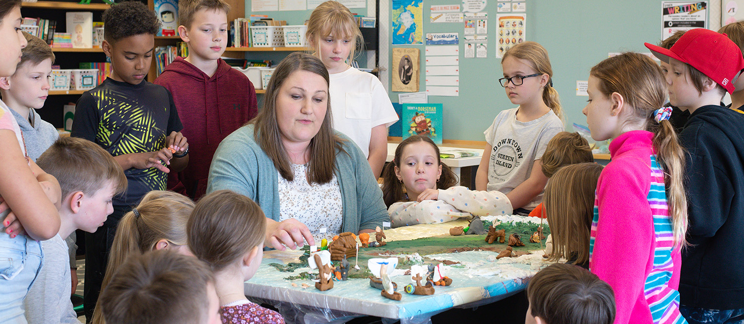
You build a 3D map of Canada so large it’s difficult to find a table big enough! At least, that is what Irene Johanson did with her enthusiastic class of grade 4 students.
Interactive Inspiration
Irene, an ACS alumni, has been a valuable part of the ACS community, playing many different roles over the years, with just as much enthusiasm as the last.
“I’ve had multiple, part-time positions at ACS, and taught every grade from kindergarten to grade 4,”she shares. “I started teaching grade 4, four years ago.”
When tasked with creating a unit project on Canada’s geography and how it affected the Indigenous peoples and first settlers of Canada, Irene came up with the three-dimensional map idea after seeing an interactive globe at the Royal Tyrell Museum in Drumheller, Alberta. As a geography major in university, Irene often looked up pictures of different geographical features discussed in her classes so she could better understand what they looked like.
She wanted to provide that same visual for her students.
Sand Dough Mountains and Clay Creations
Constructed out of sand dough, the students created a replica of Canada from a bird’s eye view, making everything from the Rocky Mountains to all the minuscule islands of Nunavut, including all major bodies of water.
“I really wanted something tangible and visual, something the students could see. I wanted to make it come alive,” she reflected, “I wanted it to be more than pen and paper.” Irene wanted her students to use real mapping skills and become true “junior cartographers” during this project.
So, she and her students looked at satellite pictures to properly depict the different climates of Canada by the colour of their terrain. They also utilized elevation maps to determine how thick the sand dough should be based on the high and low elevation points of Canada. She wanted the students to see the physical geography of the land and understand how much of an impact it made on where and how people lived.
Along with constructing the map, the students also created miniature clay figurines of the different historical people they were learning about. The clay creations were placed in specific places on the map to accurately reflect where they lived in early Canada.
Figurines of the different Indigenous groups were put on the map first, naturally, because they were here first. The various explorers, such as Jacques Cartier and John Cabot, were added and the routes of their explorations of Canada were laid out as well. The students then put on their critical thinking cap and made inferences about what aspects of Canada’s diverse geography affected each group and person. They pondered questions like, “why did some Indigenous peoples hunt bison while others’ primary food source was salmon?” and “why did the Rocky Mountains make exploration of British Columbia so difficult for the explorers?”
Off To Explore, We Go!
To further expand her student’s understanding, Irene took the students on a journey of their own. The students became their own John Cabot by exploring the elementary campus, from the staff room to a wing of the school they were not familiar with. Irene used these explorations to drum up conversations of respect. They discussed what the students did—or did not do—to respect the different spaces. “We reflected on what our wants and needs are and how we can fill those desires while still being respectful of all God has created,” she explained. They conversed on whether the explorers were respectful while fulfilling their desires for exploration when they came to Canada. Irene and her students also reflected on how they could be good stewards of God’s creation and respect all his children.
Irene recognized the importance of letting the students feel like they were a part of something. She says they loved being able to come up with their own ideas and execute them as a team under the thoughtful guidance of their teacher. “This was an opportunity to be able to imagine, to see it tangibly, to have a hands-on experience, and to be able to get involved in a class project that they all worked together to create.”
WHAT DO YOU THINK?